Geolocate

Pearl River topographic map

Click on the map to display elevation.

About this map

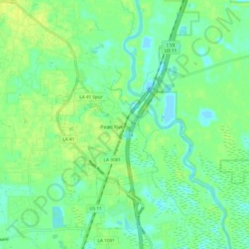
Name: Pearl River topographic map, elevation, terrain.

Location: Pearl River, St. Tammany Parish, Louisiana, 63525, United States (30.33682 -89.78414 30.41682 -89.70414)

Average elevation: 33 ft

Minimum elevation: 7 ft

Maximum elevation: 59 ft

St. Tammany Parish trails, hiking, mountain biking, running and outdoor activities

Gear up for your next adventure:

🧭Compass with Lanyard - Easy‑carry compass for navigation
🧥Men's Rain Shells - Premium waterproof and breathable jackets for mountain weather
🧤Tactile Hiking Gloves - Keep hands warm while operating GPS and smartphone screens
🧯Portable Fire Pit - Compact fire pit for camping spots
👖Convertible Hiking Pants - Versatile zip-off pants for changing altitudes and temperatures

As an Amazon Associate, this site earns from qualifying purchases at no extra cost to you.