
Make a donation
Gear up for your next adventure:
As an Amazon Associate, this site earns from qualifying purchases at no extra cost to you.
Xichuan County topographic map
Click on the map to display elevation.
Make a donation
Gear up for your next adventure:
As an Amazon Associate, this site earns from qualifying purchases at no extra cost to you.
Xichuan County
Xichuan is located south of Funiu Mountain. The county is about 107 kilometers from northwest to southeast, with a width of 46 kilometers and a total area of 2,798 square kilometers. Xichuan County is a horseshoe-shaped terrain that protrudes to the southeast in the northwest direction. The northwest is a low mountain area, the middle is a hilly area, and the southeast is a hilly and alluvial plain. Danjiangkou Reservoir is located in the south of the county. The northern and northwestern parts of the county belong to the eastern part of the Qinling mountains. On the south side of the Funiu Mountains, the mountain body is roughly east–west. The mountains about 900 meters above sea level extend from north to south. There are the Daba Mountains in the west and southwest of the county. The elevation of the east and west peaks at the junction of Zoumaling and Hubei is 1,033 meters. 1086 meters is the highest peak of the county. The east side of the Danjiangkou Reservoir belongs to the southwestern margin of the Nanyang Basin and is flat and ridge-like.
Make a donation
Gear up for your next adventure:
As an Amazon Associate, this site earns from qualifying purchases at no extra cost to you.
About this map
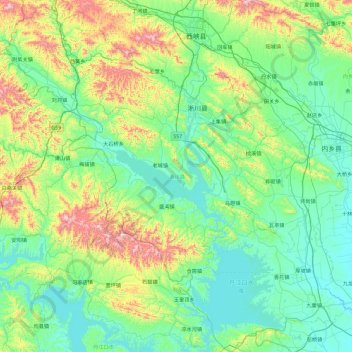
Name: Xichuan County topographic map, elevation, terrain.
Location: Xichuan County, Nanyang, Henan, China (32.59566 110.97617 33.37457 111.87366)
Average elevation: 1,047 ft
Minimum elevation: 410 ft
Maximum elevation: 3,409 ft
Make a donation
Gear up for your next adventure:
As an Amazon Associate, this site earns from qualifying purchases at no extra cost to you.