Geolocate

Torrinhas topographic map

Click on the map to display elevation.

About this map

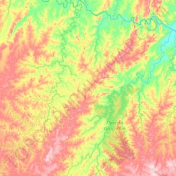
Name: Torrinhas topographic map, elevation, terrain.

Location: Torrinhas, Pinheiro Machado, Região Geográfica Imediata de Bagé, Região Geográfica Intermediária de Pelotas, Rio Grande do Sul, Região Sul, Brasil (-31.38476 -53.56773 -30.94974 -53.16551)

Average elevation: 810 ft

Minimum elevation: 289 ft

Maximum elevation: 1,516 ft

Other topographic maps

Click on a map to view its topography, its elevation and its terrain.

Porongos

Brasil > Rio Grande do Sul > Pinheiro Machado

Average elevation: 1,227 ft

Gear up for your next adventure:

📻Weather Alert Radios - Stay informed of storm risks while off-the-grid
🔭Stargazing Telescopes - Perfect for camping in low-light pollution areas shown on maps
🧣Merino Neck Gaiters - Multi-functional headwear for wind and sun protection
🛌Ultralight Sleeping Bags - Compact down bags for cold nights in the wilderness
❄️Traction Cleats - Prevent slips on icy trails during winter hikes

As an Amazon Associate, this site earns from qualifying purchases at no extra cost to you.