Geolocate

Machhor topographic map

Click on the map to display elevation.

About this map

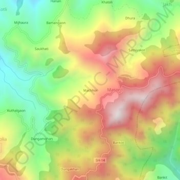
Name: Machhor topographic map, elevation, terrain.

Location: Machhor, Masord, Molekhal, Almora, Uttarakhand, 263646, India (29.57563 79.20713 29.61563 79.24713)

Average elevation: 4,347 ft

Minimum elevation: 2,690 ft

Maximum elevation: 6,109 ft

Gear up for your next adventure:

🚑Emergency Bivvies - Heat-reflective sleeping bags for survival situations
🔊Portable Camp Speaker - Music and alerts at camp
🛶Inflatable Kayak - Portable kayak for rivers, lakes, and expeditions
🦶Hiking Gaiters - Keep debris and water out of your boots
GPS Sports Watch - GPS watch for running, hiking and training

As an Amazon Associate, this site earns from qualifying purchases at no extra cost to you.