Geolocate

River topographic map

Click on the map to display elevation.

About this map

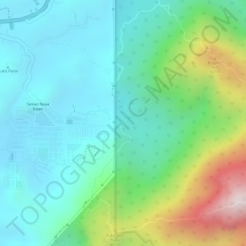
Name: River topographic map, elevation, terrain.

Location: River, Seremban, Negeri Sembilan, 70450, Malaysia (2.70530 102.02985 2.70552 102.03005)

Average elevation: 846 ft

Minimum elevation: 213 ft

Maximum elevation: 2,474 ft

Other topographic maps

Click on a map to view its topography, its elevation and its terrain.

Bukit Temiang

Malaysia > Negeri Sembilan > Seremban

Average elevation: 725 ft

Bukit Mutiara

Malaysia > Negeri Sembilan > Seremban

Average elevation: 610 ft

Gear up for your next adventure:

🔋Rechargeable Batteries - Power up your outdoor devices
🧭Orienteering Set - Complete compass and map reading kit
🪶LED Camping Lantern - Bright lantern for camp lighting
🗻Climbing Gear Basics - Essential gear for beginner climbers
📻Weather Alert Radios - Stay informed of storm risks while off-the-grid

As an Amazon Associate, this site earns from qualifying purchases at no extra cost to you.