
Make a donation
Gear up for your next adventure:
As an Amazon Associate, this site earns from qualifying purchases at no extra cost to you.
Plaus topographic map
Click on the map to display elevation.
Make a donation
Gear up for your next adventure:
As an Amazon Associate, this site earns from qualifying purchases at no extra cost to you.
About this map
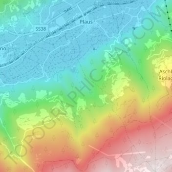
Name: Plaus topographic map, elevation, terrain.
Average elevation: 3,301 ft
Minimum elevation: 1,657 ft
Maximum elevation: 6,598 ft
Make a donation
Gear up for your next adventure:
As an Amazon Associate, this site earns from qualifying purchases at no extra cost to you.
Other topographic maps
Click on a map to view its topography, its elevation and its terrain.
Seiser Alm-Gruppe - Gruppo Mont de Sëuc - Gruppo dell'Alpe di Siusi
Italy > Trentino – Alto Adige/Südtirol > South Tyrol > Kastelruth - Castelrotto
Seiser Alm (Italian: Alpe di Siusi, Ladin: Mont Sëuc) is a Dolomite plateau and the largest high-elevation Alpine meadow (German: Alm) in Europe. Located in Italy's South Tyrol province in the Dolomites mountain range, it is a major tourist attraction, notably for skiing and hiking.
Average elevation: 4,810 ft
Piz Boè
Italy > Trentino – Alto Adige/Südtirol > South Tyrol > Corvara in Badia - Corvara
Piz Boè is the highest mountain of the Sella group, a mountain range in the Dolomites, Italy. It has an elevation of 3,152 metres (10,341 ft).
Average elevation: 8,740 ft
Gnates
Italy > Trentino – Alto Adige/Südtirol > South Tyrol > La Val - Wengen - La Valle
Average elevation: 4,934 ft
Gisse
Italy > Trentino – Alto Adige/Südtirol > South Tyrol > Ahrntal - Valle Aurina
Average elevation: 4,488 ft
Make a donation
Gear up for your next adventure:
As an Amazon Associate, this site earns from qualifying purchases at no extra cost to you.
Salotta
Italy > Trentino – Alto Adige/Südtirol > South Tyrol > San Ćiascian - St. Kassian - San Cassiano
Average elevation: 5,837 ft
Meransen - Maranza
Italy > Trentino – Alto Adige/Südtirol > South Tyrol
Meransen (Italian: Maranza) is a village in South Tyrol, Italy, in the Mühlbach municipality between Pustertal and Eisacktal. It located on the slopes of the Gitschberg mountain at an altitude of 1,414 m (4,639 ft).
Average elevation: 4,196 ft
Lengstein - Longostagno
Italy > Trentino – Alto Adige/Südtirol > South Tyrol > Ritten - Renon
Average elevation: 3,074 ft
Wahlen - Valle San Silvestro
Italy > Trentino – Alto Adige/Südtirol > South Tyrol
Average elevation: 4,885 ft
Make a donation
Gear up for your next adventure:
As an Amazon Associate, this site earns from qualifying purchases at no extra cost to you.
Klobenstein - Collalbo
Italy > Trentino – Alto Adige/Südtirol > South Tyrol > Ritten - Renon
Average elevation: 3,724 ft
Raas - Rasa
Italy > Trentino – Alto Adige/Südtirol > South Tyrol > Natz-Schabs - Naz-Sciaves
Average elevation: 2,503 ft
Make a donation
Gear up for your next adventure:
As an Amazon Associate, this site earns from qualifying purchases at no extra cost to you.
Milland - Millan
Italy > Trentino – Alto Adige/Südtirol > South Tyrol > Brixen - Bressanone
Average elevation: 2,523 ft
St. Anton
Italy > Trentino – Alto Adige/Südtirol > South Tyrol > Völs am Schlern - Fiè allo Sciliar
Average elevation: 2,638 ft
Prämajur
Italy > Trentino – Alto Adige/Südtirol > South Tyrol > Schleis - Clusio
Average elevation: 5,295 ft
Armentarola
Italy > Trentino – Alto Adige/Südtirol > South Tyrol > Badia - Abtei
Average elevation: 6,188 ft
Make a donation
Gear up for your next adventure:
As an Amazon Associate, this site earns from qualifying purchases at no extra cost to you.
Thal
Italy > Trentino – Alto Adige/Südtirol > South Tyrol > Martell - Martello
Average elevation: 5,663 ft
Weitental - Vallarga
Italy > Trentino – Alto Adige/Südtirol > South Tyrol > Vintl - Vandoies
Average elevation: 4,285 ft
Nauders - San Benedetto
Italy > Trentino – Alto Adige/Südtirol > South Tyrol
Average elevation: 3,268 ft