Geolocate

Dirleton topographic map

Click on the map to display elevation.

About this map

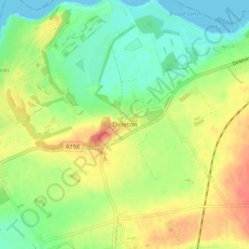
Name: Dirleton topographic map, elevation, terrain.

Location: Dirleton, East Lothian, Scotland, EH39 5ET, United Kingdom (56.02494 -2.80220 56.06494 -2.76220)

Average elevation: 79 ft

Minimum elevation: 0 ft

Maximum elevation: 174 ft

Other topographic maps

Click on a map to view its topography, its elevation and its terrain.

Firth of Forth

United Kingdom > Scotland > East Lothian

Average elevation: 285 ft

Lammermuirs

United Kingdom > Scotland > East Lothian

Average elevation: 873 ft

Bass Rock

United Kingdom > Scotland > East Lothian

Average elevation: 0 ft

River Esk

United Kingdom > Scotland > East Lothian > Musselburgh

Average elevation: 23 ft

Coldale Wood

United Kingdom > Scotland > East Lothian

Average elevation: 213 ft

Gear up for your next adventure:

🧴Hand Sanitizer - Keep hands clean while hiking
🎒Hydration Pack - Hands‑free water reservoir for long hikes
Backpacking Tent - Lightweight and durable tent for multi‑day hikes
🚗GPS Dash Cams - Record your scenic drives through mountain passes and canyons
🪄Magnetic Compass - Accurate compass for navigation

As an Amazon Associate, this site earns from qualifying purchases at no extra cost to you.