
Thank you for supporting this site ❤️
Make a donation
Make a donation
Gear up for your next adventure:
As an Amazon Associate, this site earns from qualifying purchases at no extra cost to you.
Renuka Ji topographic map
Click on the map to display elevation.
Thank you for supporting this site ❤️
Make a donation
Make a donation
Gear up for your next adventure:
As an Amazon Associate, this site earns from qualifying purchases at no extra cost to you.
About this map
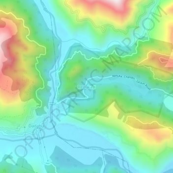
Name: Renuka Ji topographic map, elevation, terrain.
Location: Renuka Ji, Renuka, Sirmaur, Himachal Pradesh, 173022, India (30.58889 77.42937 30.62889 77.46937)
Average elevation: 2,667 ft
Minimum elevation: 2,008 ft
Maximum elevation: 4,324 ft
Thank you for supporting this site ❤️
Make a donation
Make a donation
Gear up for your next adventure:
As an Amazon Associate, this site earns from qualifying purchases at no extra cost to you.