
Thank you for supporting this site ❤️
Make a donation
Make a donation
Gear up for your next adventure:
As an Amazon Associate, this site earns from qualifying purchases at no extra cost to you.
dunki topographic map
Click on the map to display elevation.
Thank you for supporting this site ❤️
Make a donation
Make a donation
Gear up for your next adventure:
As an Amazon Associate, this site earns from qualifying purchases at no extra cost to you.
About this map
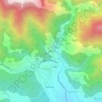
Name: dunki topographic map, elevation, terrain.
Location: dunki, Utrala, Baijnath, Kangra, Himachal Pradesh, India (32.09236 76.63051 32.13236 76.67051)
Average elevation: 5,446 ft
Minimum elevation: 3,868 ft
Maximum elevation: 8,468 ft
Thank you for supporting this site ❤️
Make a donation
Make a donation
Gear up for your next adventure:
As an Amazon Associate, this site earns from qualifying purchases at no extra cost to you.