
Make a donation
Gear up for your next adventure:
As an Amazon Associate, this site earns from qualifying purchases at no extra cost to you.
Pedro Brand topographic map
Click on the map to display elevation.
Make a donation
Gear up for your next adventure:
As an Amazon Associate, this site earns from qualifying purchases at no extra cost to you.
About this map
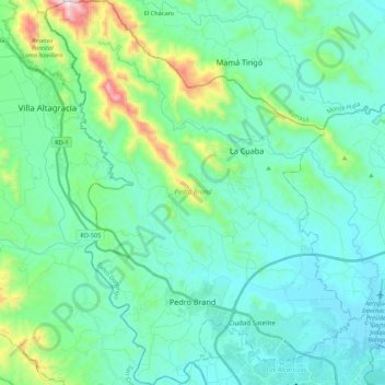
Name: Pedro Brand topographic map, elevation, terrain.
Location: Pedro Brand, Santo Domingo, Dominican Republic (18.52311 -70.17545 18.72916 -70.00206)
Average elevation: 528 ft
Minimum elevation: 13 ft
Maximum elevation: 2,858 ft
Make a donation
Gear up for your next adventure:
As an Amazon Associate, this site earns from qualifying purchases at no extra cost to you.
Other topographic maps
Click on a map to view its topography, its elevation and its terrain.
Río Isabela
Dominican Republic > Santo Domingo > Santo Domingo Norte > Villa Mella
Average elevation: 105 ft
Santo Domingo Oeste
Dominican Republic > Santo Domingo > Santo Domingo Oeste
Average elevation: 125 ft
Residencial Los Angeles
Dominican Republic > Santo Domingo > Santo Domingo Este > Residencial Los Angeles
Average elevation: 105 ft
Make a donation
Gear up for your next adventure:
As an Amazon Associate, this site earns from qualifying purchases at no extra cost to you.