Geolocate

Triora topographic map

Click on the map to display elevation.

About this map

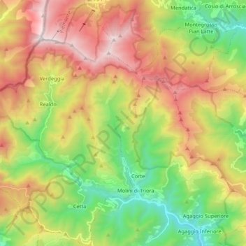
Name: Triora topographic map, elevation, terrain.

Location: Triora, Imperia, Liguria, Italy (43.96431 7.66145 44.07986 7.77957)

Average elevation: 3,770 ft

Minimum elevation: 1,138 ft

Maximum elevation: 7,172 ft

Gear up for your next adventure:

🛡️Bear Spray Outdoor - Protection in bear country hikes
🚑Emergency Bivvies - Heat-reflective sleeping bags for survival situations
Camping Coffee Makers - Enjoy premium coffee at the summit or campsite
🗺️Topographic Maps - Detailed topo maps for hiking, exploring and outdoor navigation
🦺Reflective Outdoor Gear - Safety gear for low‑light conditions

As an Amazon Associate, this site earns from qualifying purchases at no extra cost to you.