Geolocate

Muscoy topographic map

Click on the map to display elevation.

Muscoy

Muscoy is located at 34°9′22″N 117°20′48″W / 34.15611°N 117.34667°W / 34.15611; -117.34667 (34.156009, -117.346552). Elevation ranges from 1240' in the south to 1600' in the north.

Wikipedia (CC-BY-SA 3.0)

About this map

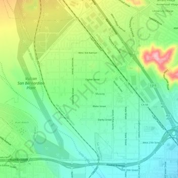
Name: Muscoy topographic map, elevation, terrain.

Location: Muscoy, Rialto, San Bernardino County, California, United States (34.13599 -117.38940 34.17448 -117.33102)

Average elevation: 1,421 ft

Minimum elevation: 1,201 ft

Maximum elevation: 1,850 ft

San Bernardino County trails, hiking, mountain biking, running and outdoor activities

Gear up for your next adventure:

🗺️NatGeo Topo Maps - High-quality waterproof printed topographic maps of US Parks
🪵Folding Camp Saw - Compact saw for wood and campsite work
👓Polarized Sunglasses - Outdoor sunglasses for glare reduction
🚑Emergency Bivvies - Heat-reflective sleeping bags for survival situations
🧭Outdoor Navigation Book - Learn advanced navigation skills

As an Amazon Associate, this site earns from qualifying purchases at no extra cost to you.