
Tiffin topographic map
Click on the map to display elevation.
About this map
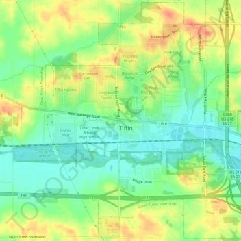
Name: Tiffin topographic map, elevation, terrain.
Location: Tiffin, Johnson County, Iowa, 52340, United States (41.68698 -91.69093 41.72716 -91.63419)
Average elevation: 745 ft
Minimum elevation: 669 ft
Maximum elevation: 833 ft
Johnson County trails, hiking, mountain biking, running and outdoor activities
Other topographic maps
Click on a map to view its topography, its elevation and its terrain.
Iowa City
United States > Iowa > Johnson County > Iowa City
The elevation at the Iowa City Municipal Airport is 668 ft (203.6 m) above sea level.
Average elevation: 738 ft