
Cosgrove topographic map
Click on the map to display elevation.
About this map
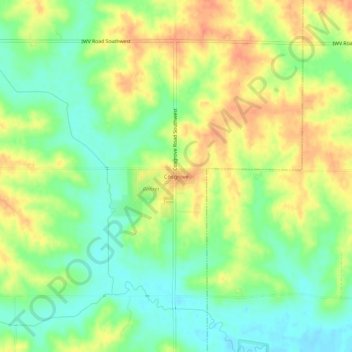
Name: Cosgrove topographic map, elevation, terrain.
Location: Cosgrove, Johnson County, Iowa, 52244, United States (41.62279 -91.75573 41.66279 -91.71573)
Average elevation: 748 ft
Minimum elevation: 676 ft
Maximum elevation: 823 ft
Other topographic maps
Click on a map to view its topography, its elevation and its terrain.
Iowa City
United States > Iowa > Johnson County
The elevation at the Iowa City Municipal Airport is 668 ft (203.6 m) above sea level.
Average elevation: 709 ft
North Liberty
United States > Iowa > Johnson County
North Liberty is located on the Iowan erosion surface. Drivers on I-380 experience an abrupt transition from the muted topography of the Iowan surface to the rolling hills of the Southern Iowa drift plain, four miles south of North Liberty.
Average elevation: 771 ft
Iowa City
United States > Iowa > Johnson County
The elevation at the Iowa City Municipal Airport is 668 ft (204 m) above sea level.
Average elevation: 709 ft
Iowa City
United States > Iowa > Johnson County
The elevation at the Iowa City Municipal Airport is 668 ft (204 m) above sea level.
Average elevation: 709 ft
Iowa City
United States > Iowa > Johnson County
The elevation at the Iowa City Municipal Airport is 668 ft (204 m) above sea level.
Average elevation: 709 ft