Geolocate

Midway topographic map

Click on the map to display elevation.

About this map

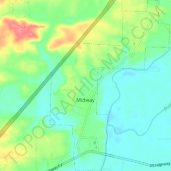
Name: Midway topographic map, elevation, terrain.

Location: Midway, Hot Spring County, Arkansas, 71941, United States (34.23266 -92.98006 34.28578 -92.93484)

Average elevation: 282 ft

Minimum elevation: 197 ft

Maximum elevation: 479 ft

Hot Spring County trails, hiking, mountain biking, running and outdoor activities

Other topographic maps

Click on a map to view its topography, its elevation and its terrain.

Bonnerdale

United States > Arkansas > Hot Spring County

Average elevation: 663 ft

Social Hill

United States > Arkansas > Hot Spring County

Average elevation: 302 ft

Saginaw

United States > Arkansas > Hot Spring County

Average elevation: 305 ft

Magnet Cove

United States > Arkansas > Hot Spring County

Average elevation: 512 ft

Glen Rose

United States > Arkansas > Hot Spring County

Average elevation: 351 ft

Lono

United States > Arkansas > Hot Spring County

Average elevation: 463 ft

Perla

United States > Arkansas > Hot Spring County > Perla

Average elevation: 358 ft

Gear up for your next adventure:

🎒Hydration Pack - Hands‑free water reservoir for long hikes
🧤Tactile Hiking Gloves - Keep hands warm while operating GPS and smartphone screens
🖼️Topo Map Wall Art - Decorative topographic prints of famous peaks and regions
🔌Solar Panel Charger - Charge gear sustainably outdoors
☀️Outdoor Sunscreen - High protection sunscreen for outdoor activities

As an Amazon Associate, this site earns from qualifying purchases at no extra cost to you.