
Make a donation
Gear up for your next adventure:
As an Amazon Associate, this site earns from qualifying purchases at no extra cost to you.
Edgerton topographic map
Click on the map to display elevation.
Make a donation
Gear up for your next adventure:
As an Amazon Associate, this site earns from qualifying purchases at no extra cost to you.
About this map
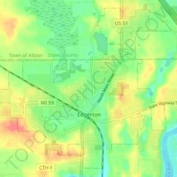
Name: Edgerton topographic map, elevation, terrain.
Location: Edgerton, Rock County, Wisconsin, 53534, United States (42.81960 -89.10217 42.86066 -89.04048)
Average elevation: 856 ft
Minimum elevation: 774 ft
Maximum elevation: 958 ft
Rock County trails, hiking, mountain biking, running and outdoor activities
Make a donation
Gear up for your next adventure:
As an Amazon Associate, this site earns from qualifying purchases at no extra cost to you.
Other topographic maps
Click on a map to view its topography, its elevation and its terrain.
Johnstown Center
United States > Wisconsin > Rock County > Town of Johnstown
Average elevation: 951 ft
Make a donation
Gear up for your next adventure:
As an Amazon Associate, this site earns from qualifying purchases at no extra cost to you.