Geolocate

Avalon topographic map

Click on the map to display elevation.

About this map

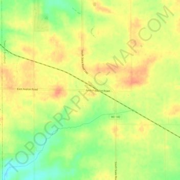
Name: Avalon topographic map, elevation, terrain.

Location: Avalon, Town of Bradford, Rock County, Wisconsin, 53505, United States (42.61279 -88.88761 42.65279 -88.84761)

Average elevation: 948 ft

Minimum elevation: 863 ft

Maximum elevation: 1,001 ft

Rock County trails, hiking, mountain biking, running and outdoor activities

Other topographic maps

Click on a map to view its topography, its elevation and its terrain.

Town of Center

United States > Wisconsin > Rock County

Average elevation: 912 ft

Town of Fulton

United States > Wisconsin > Rock County

Average elevation: 860 ft

Orfordville

United States > Wisconsin > Rock County

Orfordville is located at 42°37′45″N 89°15′24″W / 42.62917°N 89.25667°W / 42.62917; -89.25667 (42.629300, −89.256755). The elevation is 889 feet (271 m).

Average elevation: 915 ft

Footville

United States > Wisconsin > Rock County

Average elevation: 856 ft

Edgerton

United States > Wisconsin > Rock County

Average elevation: 856 ft

Evansville

United States > Wisconsin > Rock County

Average elevation: 922 ft

Town of La Prairie

United States > Wisconsin > Rock County

Average elevation: 863 ft

Town of Janesville

United States > Wisconsin > Rock County

Average elevation: 899 ft

Milton

United States > Wisconsin > Rock County

Average elevation: 889 ft

Town of Bradford

United States > Wisconsin > Rock County

Average elevation: 919 ft

Gear up for your next adventure:

💧Water Purification System - Clean water on the trail with reliable purifiers
🧣Merino Neck Gaiters - Multi-functional headwear for wind and sun protection
🥾Hiking Shoes - Durable and comfortable shoes for trail hiking
🎒Outdoor Daypacks - Lightweight backpacks designed for carrying maps and essential gear
🔋Solar Power Banks - Keep your GPS and phone charged in remote wilderness areas

As an Amazon Associate, this site earns from qualifying purchases at no extra cost to you.