Geolocate

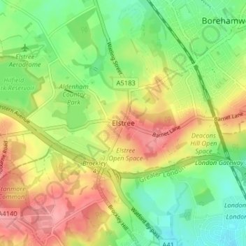
Elstree topographic map

Click on the map to display elevation.

Elstree

In 1723, topographer John Norden noted in his book Speculum Britanniae, that in the county of Hartfordshire [sic] was one "Elstre or Eglestre". In an earlier edition, he writes.

Wikipedia (CC-BY-SA 3.0)

About this map

Name: Elstree topographic map, elevation, terrain.

Location: Elstree, Hertsmere, Hertfordshire, England, WD6 3BY, United Kingdom (51.62377 -0.31893 51.66377 -0.27893)

Average elevation: 344 ft

Minimum elevation: 210 ft

Maximum elevation: 499 ft

Other topographic maps

Click on a map to view its topography, its elevation and its terrain.
Shenley

United Kingdom > England > Hertfordshire > Hertsmere

Average elevation: 318 ft

Aldenham

United Kingdom > England > Hertfordshire > Hertsmere

Average elevation: 269 ft

Aldenham

United Kingdom > England > Hertfordshire > Hertsmere

Average elevation: 269 ft

Gear up for your next adventure:

🥾Hiking Shoes - Durable and comfortable shoes for trail hiking
🛌Ultralight Sleeping Bags - Compact down bags for cold nights in the wilderness
🔌USB Car Charger - Car charger for on‑the‑go power needs
🪶Fire Starter Kit - Reliable fire starter for survival and camping
🦶Hiking Gaiters - Keep debris and water out of your boots

As an Amazon Associate, this site earns from qualifying purchases at no extra cost to you.