
Thank you for supporting this site ❤️
Make a donation
Make a donation
Gear up for your next adventure:
As an Amazon Associate, this site earns from qualifying purchases at no extra cost to you.
Billekh topographic map
Click on the map to display elevation.
Thank you for supporting this site ❤️
Make a donation
Make a donation
Gear up for your next adventure:
As an Amazon Associate, this site earns from qualifying purchases at no extra cost to you.
About this map
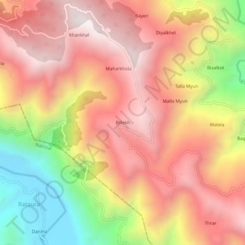
Name: Billekh topographic map, elevation, terrain.
Location: Billekh, Ranikhet, Almora District, Uttarakhand, India (29.54166 79.40047 29.58166 79.44047)
Average elevation: 4,892 ft
Minimum elevation: 2,602 ft
Maximum elevation: 6,427 ft
Thank you for supporting this site ❤️
Make a donation
Make a donation
Gear up for your next adventure:
As an Amazon Associate, this site earns from qualifying purchases at no extra cost to you.