Geolocate

Pallua Sur topographic map

Click on the map to display elevation.

About this map
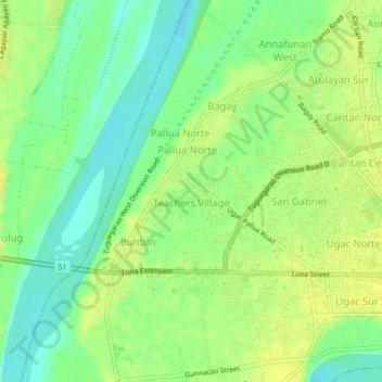
Name: Pallua Sur topographic map, elevation, terrain.

Location: Pallua Sur, Tuguegarao, Cagayan, Cagayan Valley, 3500, Philippines (17.60201 121.68237 17.64201 121.72237)

Average elevation: 72 ft

Minimum elevation: 33 ft

Maximum elevation: 102 ft

Other topographic maps

Click on a map to view its topography, its elevation and its terrain.
Centro X

Philippines > Cagayan > Tuguegarao > Capatan

Average elevation: 72 ft

Centro XII

Philippines > Cagayan > Tuguegarao > Balzain West

Average elevation: 82 ft

Centro V

Philippines > Cagayan > Tuguegarao

Average elevation: 72 ft

Pinancauanan River

Philippines > Cagayan > Tuguegarao > Capatan

Average elevation: 335 ft

Centro IX

Philippines > Cagayan > Tuguegarao

Average elevation: 69 ft

Gear up for your next adventure:

📷Action Camera - Capture your outdoor adventures in HD
👟Men's Trail Runners - Lightweight footwear for fast-paced exploration and light hiking
📶Vehicle Signal Boosters - Improve reception in rural areas while driving to trailheads
🧢Sun Protection Hats - Wide-brimmed and UPF-rated hats for high-altitude sun safety
🧦Hiking Socks - Comfortable socks to prevent blisters on long hikes

As an Amazon Associate, this site earns from qualifying purchases at no extra cost to you.