Geolocate

Condom topographic map

Click on the map to display elevation.

About this map

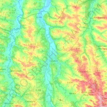
Name: Condom topographic map, elevation, terrain.

Location: Condom, Gers, Occitania, Metropolitan France, 32100, France (43.90095 0.29976 44.02956 0.45674)

Average elevation: 417 ft

Minimum elevation: 210 ft

Maximum elevation: 764 ft

Other topographic maps

Click on a map to view its topography, its elevation and its terrain.

Gascony

France > Occitania > Gers > Bazian

Average elevation: 1,348 ft

Pris

France > Occitania > Gers > Eauze

Average elevation: 502 ft

A las Costes

France > Occitania > Gers > Castelnau-Barbarens

Average elevation: 682 ft

Gear up for your next adventure:

🥾Hiking Shoes - Durable and comfortable shoes for trail hiking
🛌Ultralight Sleeping Bags - Compact down bags for cold nights in the wilderness
🚗GPS Dash Cams - Record your scenic drives through mountain passes and canyons
Solar GPS Watches - Advanced multisport watches with built-in topographic maps
🛡️Bear Spray Outdoor - Protection in bear country hikes

As an Amazon Associate, this site earns from qualifying purchases at no extra cost to you.