
Make a donation
Gear up for your next adventure:
As an Amazon Associate, this site earns from qualifying purchases at no extra cost to you.
Dominica topographic map
Click on the map to display elevation.
Make a donation
Gear up for your next adventure:
As an Amazon Associate, this site earns from qualifying purchases at no extra cost to you.
Dominica
Dominica (locally /ˌdɒmɪˈniːkə/ dom-in-EE-kə; UK: US: /ˌdɒmɪˈniːkə/ or /dəˈmɪnɪkə/ (listen); Kalinago: Wai‘tu kubuli; French: Dominique; Dominican Creole French: Dominik), officially the Commonwealth of Dominica, is an island country in the Caribbean. The capital, Roseau, is located on the western side of the island. It is geographically situated as part of the Windward Islands chain in the Lesser Antilles archipelago in the Caribbean Sea. Dominica's closest neighbours are two constituent territories of the European Union, the overseas departments of France, Guadeloupe to the northwest and Martinique to the south-southeast. Dominica comprises a land area of 750 km2 (290 sq mi), and the highest point is Morne Diablotins, at 1,447 m (4,747 ft) in elevation. Its population was 71,293 at the 2011 census.
Make a donation
Gear up for your next adventure:
As an Amazon Associate, this site earns from qualifying purchases at no extra cost to you.
About this map
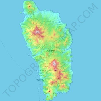
Name: Dominica topographic map, elevation, terrain.
Location: Dominica, City of Roseau, Saint Joseph Parish, Dominica (15.20763 -61.48012 15.64028 -61.24009)
Average elevation: 374 ft
Minimum elevation: 0 ft
Maximum elevation: 4,521 ft
Make a donation
Gear up for your next adventure:
As an Amazon Associate, this site earns from qualifying purchases at no extra cost to you.