Geolocate

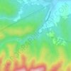
Voćin topographic map

Click on the map to display elevation.

About this map

Name: Voćin topographic map, elevation, terrain.

Location: Voćin, Općina Voćin, Virovitica-Podravina County, 33522, Croatia (45.55674 17.42125 45.64897 17.59082)

Average elevation: 1,266 ft

Minimum elevation: 482 ft

Maximum elevation: 2,877 ft

Other topographic maps

Click on a map to view its topography, its elevation and its terrain.
Rupnica

Croatia > Virovitica-Podravina County

Average elevation: 1,066 ft

Gear up for your next adventure:

🏔️Mountain Trail Maps - High‑detail maps for popular peaks
🌎3D Topographic Globes - Raised relief globes for a tactile understanding of geography
🥾Hiking Shoes - Durable and comfortable shoes for trail hiking
📶Satellite Messenger - Communication device off‑grid
🔥Plasma Lighters - Windproof lighters that work in any weather condition

As an Amazon Associate, this site earns from qualifying purchases at no extra cost to you.