Geolocate

Bethany topographic map

Click on the map to display elevation.

About this map

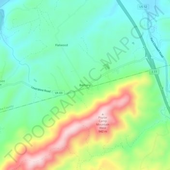
Name: Bethany topographic map, elevation, terrain.

Location: Bethany, Wythe County, Virginia, 24312, United States (36.82373 -80.90036 36.86373 -80.86036)

Average elevation: 2,303 ft

Minimum elevation: 1,936 ft

Maximum elevation: 3,035 ft

Wythe County trails, hiking, mountain biking, running and outdoor activities

Other topographic maps

Click on a map to view its topography, its elevation and its terrain.

Rural Retreat

United States > Virginia > Wythe County

Average elevation: 2,549 ft

Fort Chiswell

United States > Virginia > Wythe County > Fort Chiswell

Average elevation: 2,211 ft

Gear up for your next adventure:

📡Handheld GPS Device - Reliable handheld GPS for outdoor navigation
🥤Water Filter Bottle - All‑in‑one filter bottle for safe hydration
🔋Solar Power Banks - Keep your GPS and phone charged in remote wilderness areas
🏥Hiking First Aid Kits - Comprehensive medical kits for remote trail injuries
🔌USB Car Charger - Car charger for on‑the‑go power needs

As an Amazon Associate, this site earns from qualifying purchases at no extra cost to you.