Geolocate

Hammer topographic map

Click on the map to display elevation.

About this map

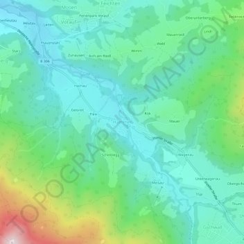
Name: Hammer topographic map, elevation, terrain.

Location: Hammer, Siegsdorf, Landkreis Traunstein, Bayern, 83313, Deutschland (47.78105 12.68430 47.82105 12.72430)

Average elevation: 2,487 ft

Minimum elevation: 2,008 ft

Maximum elevation: 3,963 ft

Other topographic maps

Click on a map to view its topography, its elevation and its terrain.

Hörgering

Deutschland > Bayern > Landkreis Traunstein > Siegsdorf

Average elevation: 2,369 ft

83313

Deutschland > Bayern > Landkreis Traunstein > Siegsdorf > Wolfsberg > Starz

Average elevation: 2,349 ft

Gear up for your next adventure:

🔦Compact Flashlight - Reliable flashlight for emergencies
🦶Carbon Trekking Poles - Reduce knee impact on steep descents with ultra-light poles
🩳Quick‑Dry Hiking Shorts - Comfortable and quick‑dry shorts for summer hiking
📖Nature Tracking Books - Learn to track wildlife and terrain
🏕️Family Camping Gear - Essentials for group camping trips

As an Amazon Associate, this site earns from qualifying purchases at no extra cost to you.