
Make a donation
Gear up for your next adventure:
As an Amazon Associate, this site earns from qualifying purchases at no extra cost to you.
Shuili Township topographic map
Click on the map to display elevation.
Make a donation
Gear up for your next adventure:
As an Amazon Associate, this site earns from qualifying purchases at no extra cost to you.
About this map
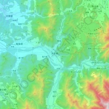
Name: Shuili Township topographic map, elevation, terrain.
Location: Shuili Township, Nantou County, Taiwan (23.71081 120.81027 23.90748 120.93695)
Average elevation: 2,201 ft
Minimum elevation: 430 ft
Maximum elevation: 8,678 ft
Make a donation
Gear up for your next adventure:
As an Amazon Associate, this site earns from qualifying purchases at no extra cost to you.
Other topographic maps
Click on a map to view its topography, its elevation and its terrain.
Yushan
Taiwan > Nantou County > Xinyi Township
Yu Shan or Yushan, also known as Mount Jade, Jade Mountain, Tongku Saveq or Mount Niitaka during Japanese rule, is the highest mountain in Taiwan at 3,952 m (12,966 ft) above sea level, giving Taiwan the 4th-highest maximum elevation of any island in the world. It is the highest point in the western Pacific…
Average elevation: 11,191 ft