Geolocate

Seaham topographic map

Click on the map to display elevation.

About this map

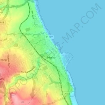
Name: Seaham topographic map, elevation, terrain.

Location: Seaham, County Durham, North East, England, United Kingdom (54.81751 -1.37868 54.86072 -1.31863)

Average elevation: 102 ft

Minimum elevation: 0 ft

Maximum elevation: 384 ft

Other topographic maps

Click on a map to view its topography, its elevation and its terrain.

Hamsterley

United Kingdom > England > County Durham

Average elevation: 433 ft

Toft Hill

United Kingdom > England > County Durham

Average elevation: 525 ft

New Brancepeth

United Kingdom > England > County Durham

Average elevation: 463 ft

Carrville

United Kingdom > England > County Durham

Average elevation: 246 ft

Gear up for your next adventure:

🩳Quick‑Dry Hiking Shorts - Comfortable and quick‑dry shorts for summer hiking
🥘Titanium Cookware - Durable, featherlight pots and pans for backpacking
🕶️GPS Smartphone Mount - Secure mount for phone navigation
🥇GPS Hiking Watch - Multi‑sport GPS watch with navigation and trail tracking
🧦Hiking Socks - Comfortable socks to prevent blisters on long hikes

As an Amazon Associate, this site earns from qualifying purchases at no extra cost to you.