Geolocate

Ralston topographic map

Click on the map to display elevation.

About this map
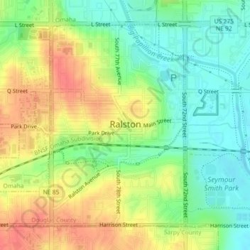
Name: Ralston topographic map, elevation, terrain.

Location: Ralston, Douglas Precinct, Douglas County, Nebraska, United States (41.19064 -96.05241 41.21247 -96.02369)

Average elevation: 1,076 ft

Minimum elevation: 988 ft

Maximum elevation: 1,178 ft

Douglas County trails, hiking, mountain biking, running and outdoor activities

Other topographic maps

Click on a map to view its topography, its elevation and its terrain.

Elmwood Park

United States > Nebraska > Douglas County > Omaha

Average elevation: 1,129 ft

King Lake

United States > Nebraska > Douglas County

Average elevation: 1,132 ft

Benson Park Lagoon

United States > Nebraska > Douglas County > Omaha

Average elevation: 1,175 ft

Elkhorn City Park

United States > Nebraska > Douglas County > Omaha

Average elevation: 1,220 ft

Irvington

United States > Nebraska > Douglas County

Average elevation: 1,165 ft

Discovery Garden

United States > Nebraska > Douglas County > Omaha

Average elevation: 1,096 ft

Gear up for your next adventure:

🦶Hiking Gaiters - Keep debris and water out of your boots
🩳Quick‑Dry Hiking Shorts - Comfortable and quick‑dry shorts for summer hiking
🪵Folding Camp Saw - Compact saw for wood and campsite work
🔦Compact Flashlight - Reliable flashlight for emergencies
🖼️Topo Map Wall Art - Decorative topographic prints of famous peaks and regions

As an Amazon Associate, this site earns from qualifying purchases at no extra cost to you.