
Make a donation
Gear up for your next adventure:
As an Amazon Associate, this site earns from qualifying purchases at no extra cost to you.
Lacy-Lakeview topographic map
Click on the map to display elevation.
Make a donation
Gear up for your next adventure:
As an Amazon Associate, this site earns from qualifying purchases at no extra cost to you.
About this map
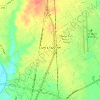
Name: Lacy-Lakeview topographic map, elevation, terrain.
Location: Lacy-Lakeview, McLennan County, Texas, United States (31.59948 -97.12814 31.65843 -97.08235)
Average elevation: 472 ft
Minimum elevation: 390 ft
Maximum elevation: 558 ft
McLennan County trails, hiking, mountain biking, running and outdoor activities
Make a donation
Gear up for your next adventure:
As an Amazon Associate, this site earns from qualifying purchases at no extra cost to you.
Other topographic maps
Click on a map to view its topography, its elevation and its terrain.
Make a donation
Gear up for your next adventure:
As an Amazon Associate, this site earns from qualifying purchases at no extra cost to you.
Northcrest
United States > Texas > McLennan County > Lacy-Lakeview > Northcrest
Average elevation: 489 ft
Make a donation
Gear up for your next adventure:
As an Amazon Associate, this site earns from qualifying purchases at no extra cost to you.