
Thank you for supporting this site ❤️
Make a donation
Make a donation
Gear up for your next adventure:
As an Amazon Associate, this site earns from qualifying purchases at no extra cost to you.
Malz topographic map
Click on the map to display elevation.
Thank you for supporting this site ❤️
Make a donation
Make a donation
Gear up for your next adventure:
As an Amazon Associate, this site earns from qualifying purchases at no extra cost to you.
About this map
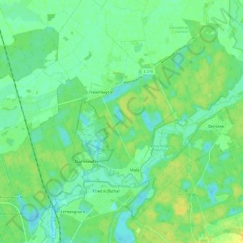
Name: Malz topographic map, elevation, terrain.
Location: Malz, Oranienburg, Oberhavel, Brandenburg, Deutschland (52.78797 13.24071 52.84647 13.35967)
Average elevation: 131 ft
Minimum elevation: 102 ft
Maximum elevation: 171 ft
Thank you for supporting this site ❤️
Make a donation
Make a donation
Gear up for your next adventure:
As an Amazon Associate, this site earns from qualifying purchases at no extra cost to you.
Other topographic maps
Click on a map to view its topography, its elevation and its terrain.
Glashütte
Deutschland > Brandenburg > Oberhavel > Oranienburg > Fichtengrund
Average elevation: 125 ft