Crooked River topographic map
Interactive map
Click on the map to display elevation.
About this map
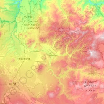
Name: Crooked River topographic map, elevation, terrain.
Location: Crooked River, Oregon, United States (44.08457 -121.30230 44.57367 -120.05273)
Average elevation: 3,711 ft
Minimum elevation: 1,378 ft
Maximum elevation: 6,870 ft
The Lower Crooked Wild and Scenic River flows through 2,300 acres (930 ha) of public lands overseen by the Bureau of Land Management and 220 acres (89 ha) overseen by the Bureau of Reclamation. The Chimney Rock segment below Bowman Dam has nine developed campsites, seven of which are meant for single-family camping, and two that are multi-family or group sites. All are fee sites; all have toilets; only one, Chimney Rock, has drinking water. Opposite the Chimney Rock Campground is the trailhead for Chimney Rock Trail, which winds up a side canyon for 1.3 miles (2.1 km) to higher-elevation views of the main canyon and the Cascade Range. The BLM also oversees two day-use sites along this stretch of the river. All of these installations are connected by Oregon Route 27, which follows the river between the dam and Prineville.
Other topographic maps
Click on a map to view its topography, its elevation and its terrain.
Beaverton
United States > Oregon > Washington County
Beaverton, Washington County, Oregon, United States
Average elevation: 348 ft
Arlington
United States > Oregon > Gilliam County
Arlington, Gilliam County, Oregon, United States
Average elevation: 479 ft
Oregon City
United States > Oregon > Clackamas County
Oregon City, Clackamas County, Oregon, 97045, United States
Average elevation: 325 ft
South Beaverton
United States > Oregon > Washington County > Beaverton
South Beaverton, Beaverton, Washington County, Oregon, United States
Average elevation: 259 ft
Bull Mountain
United States > Oregon > Crook County
Bull Mountain, Crook County, Oregon, United States
Average elevation: 4,557 ft
Tigard
United States > Oregon > Washington County
Tigard, Washington County, Oregon, United States
Average elevation: 272 ft
Klamath Falls
United States > Oregon > Klamath County
Klamath Falls, Klamath County, Oregon, 97601, United States
Average elevation: 4,304 ft
Creswell
United States > Oregon > Lane County
Creswell, Lane County, Oregon, 97426, United States
Average elevation: 541 ft
Gresham
United States > Oregon > Multnomah County
Gresham, Multnomah County, Oregon, United States
Average elevation: 295 ft
Umatilla County
Umatilla County, Oregon, United States, Round Mountain
Average elevation: 4,104 ft
Bend
United States > Oregon > Deschutes County
Bend, Deschutes County, Oregon, United States
Average elevation: 3,678 ft
Caufield
United States > Oregon > Clackamas County > Oregon City
Caufield, Oregon City, Clackamas County, Oregon, United States
Average elevation: 417 ft
Davidson Park
United States > Oregon > Crook County > Prineville
Davidson Park, Prineville, Crook County, Oregon, United States
Average elevation: 2,907 ft
Kent
United States > Oregon > Sherman County
Kent, Sherman County, Oregon, 97033, United States
Average elevation: 2,661 ft
Mount Scott
United States > Oregon > Klamath County
Mount Scott, Klamath County, Oregon, United States
Average elevation: 7,530 ft
Medford
United States > Oregon > Jackson County
Medford, Jackson County, Oregon, United States
Average elevation: 1,447 ft
Bald Hill
United States > Oregon > Union County
Bald Hill, Union County, Oregon, United States
Average elevation: 4,918 ft
Mount Richmond
United States > Oregon > Yamhill County
Mount Richmond, Yamhill County, Oregon, United States
Average elevation: 715 ft
Washington County
Washington County, Oregon, United States
Average elevation: 699 ft
Blue Lake
United States > Oregon > Wallowa County
Blue Lake, Wallowa County, Oregon, United States
Average elevation: 7,726 ft
Eagle Point
United States > Oregon > Jackson County
Eagle Point, Jackson County, Oregon, 97524, United States
Average elevation: 1,385 ft
Happy Valley
United States > Oregon > Clackamas County > Happy Valley
Happy Valley, Clackamas County, Oregon, 97086, United States
Average elevation: 453 ft
Fairy Falls
United States > Oregon > Multnomah County
Fairy Falls, Multnomah County, Oregon, 97010, United States
Average elevation: 1,234 ft
Three Sisters
United States > Oregon > Deschutes County
Three Sisters, Deschutes County, Oregon, United States
Average elevation: 8,287 ft
Myrtle Creek
United States > Oregon > Douglas County
Myrtle Creek, Douglas County, Oregon, United States
Average elevation: 909 ft
Moro
United States > Oregon > Sherman County > Moro
Moro, Sherman County, Oregon, 97039, United States
Average elevation: 1,926 ft
Bradwood
United States > Oregon > Clatsop County > Bradwood
Bradwood, Clatsop County, Oregon, United States
Average elevation: 157 ft
Hermiston
United States > Oregon > Umatilla County > Hermiston
Hermiston, Umatilla County, Oregon, 97838, United States
Average elevation: 525 ft
Damascus
United States > Oregon > Clackamas County > Damascus
Damascus, Clackamas County, Oregon, 97089, United States
Average elevation: 489 ft
Walker Creek
United States > Oregon > Ashland
Walker Creek, Ashland, Jackson County, Oregon, 95520, United States
Average elevation: 1,962 ft
Eugene
United States > Oregon > Lane County
Eugene, Lane County, Oregon, United States
Average elevation: 535 ft
Woodburn
United States > Oregon > Marion County
Woodburn, Marion County, Oregon, 97071, United States
Average elevation: 180 ft
Adel
United States > Oregon > Adel
Adel, Lake County, Oregon, 97620, United States
Average elevation: 4,813 ft
Seal Rocks
Seal Rocks, Lincoln County, Oregon, 97376, United States
Average elevation: 351 ft
Portland
United States > Oregon > Multnomah County
Portland, Multnomah County, Oregon, United States
Average elevation: 253 ft
Mount Hood
United States > Oregon > Hood River County
Mount Hood, Hood River County, Oregon, United States
Average elevation: 8,911 ft
McIntyre
United States > Oregon > Umatilla County
McIntyre, Umatilla County, Oregon, United States
Average elevation: 4,767 ft
Donald
United States > Oregon > Marion County
Donald, Marion County, Oregon, 97020, United States
Average elevation: 184 ft
Gilbert River
Gilbert River, Columbia County, Oregon, United States
Average elevation: 16 ft
Macleay
United States > Oregon > Marion County > Macleay
Macleay, Marion County, Oregon, United States
Average elevation: 443 ft
Salem
United States > Oregon > Marion County
Salem, Marion County, Oregon, United States
Average elevation: 315 ft
Mapleton
United States > Oregon > Mapleton
Mapleton, Lane County, Oregon, 97453, United States
Average elevation: 430 ft
Tillamook County
Tillamook County, Oregon, United States
Average elevation: 774 ft
Multnomah County
Multnomah County, Oregon, United States
Average elevation: 1,096 ft
Hood River County
Hood River County, Oregon, United States
Average elevation: 2,822 ft
Latham
United States > Oregon > Latham
Latham, Lane County, Oregon, 97424-1918, United States
Average elevation: 833 ft