Geolocate

Ackley topographic map

Click on the map to display elevation.

About this map

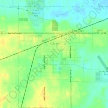
Name: Ackley topographic map, elevation, terrain.

Location: Ackley, Hardin County, Iowa, 50601, United States (42.53627 -93.06609 42.56583 -93.02688)

Average elevation: 1,086 ft

Minimum elevation: 1,043 ft

Maximum elevation: 1,132 ft

Hardin County trails, hiking, mountain biking, running and outdoor activities

Other topographic maps

Click on a map to view its topography, its elevation and its terrain.

Garden City

United States > Iowa > Hardin County

Average elevation: 1,178 ft

Gifford

United States > Iowa > Hardin County

Average elevation: 971 ft

Gear up for your next adventure:

GPS Sports Watch - GPS watch for running, hiking and training
🚑Emergency Bivvies - Heat-reflective sleeping bags for survival situations
🔥Camping Stove - Portable stove for camping and backcountry cooking
🔋Solar Power Banks - Keep your GPS and phone charged in remote wilderness areas
🔭Stargazing Telescopes - Perfect for camping in low-light pollution areas shown on maps

As an Amazon Associate, this site earns from qualifying purchases at no extra cost to you.