
Make a donation
Gear up for your next adventure:
As an Amazon Associate, this site earns from qualifying purchases at no extra cost to you.
Docking topographic map
Click on the map to display elevation.
Make a donation
Gear up for your next adventure:
As an Amazon Associate, this site earns from qualifying purchases at no extra cost to you.
Docking
Docking village in the centre of the parish is situated at an elevation of 82.7 metres (272 feet), which makes it one of the highest in Norfolk. It is surrounded by arable farmland having little woodland and is a nucleated settlement, with only one historical hamlet associated with it. This is Summerfield to the north-west, the site of a separate medieval village. The two modern hamlets in the parish are Burntstalk to the west around the former workhouse, and Docking Common to the south-east which postdates the enclosure of the village common in 1859.
Make a donation
Gear up for your next adventure:
As an Amazon Associate, this site earns from qualifying purchases at no extra cost to you.
About this map
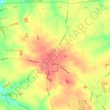
Name: Docking topographic map, elevation, terrain.
Average elevation: 207 ft
Minimum elevation: 66 ft
Maximum elevation: 308 ft
Make a donation
Gear up for your next adventure:
As an Amazon Associate, this site earns from qualifying purchases at no extra cost to you.
Other topographic maps
Click on a map to view its topography, its elevation and its terrain.
King's Lynn
United Kingdom > England > Norfolk > King's Lynn and West Norfolk
Average elevation: 23 ft