
Whittier topographic map
Click on the map to display elevation.
About this map
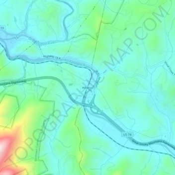
Name: Whittier topographic map, elevation, terrain.
Location: Whittier, Swain County, North Carolina, 28789, United States (35.41510 -83.38015 35.45510 -83.34015)
Average elevation: 2,047 ft
Minimum elevation: 1,778 ft
Maximum elevation: 3,127 ft
Swain County trails, hiking, mountain biking, running and outdoor activities
Other topographic maps
Click on a map to view its topography, its elevation and its terrain.
Fontana Dam
United States > North Carolina > Swain County
Fontana Dam is 2,365 feet (721 m) long and 480 feet (146 m) high, making it the tallest dam in the Eastern United States. The dam has a flood storage capacity of 513,965 acre-feet (633,966,000 m3), and the combined capacity of its three generators is 293.6 megawatts. Fontana Lake has 238 miles (383 km) of…
Average elevation: 1,722 ft
Fontana Lake
United States > North Carolina > Swain County
Fontana Lake provides the only access into the most remote areas of the National Park, unless visitors undertake a multi-day hike to get there. When the lake is at the normal summer level, a boat may be used to access remote trailheads such as Hazel Creek. From the observation tower on Kuwohi, on a clear day…
Average elevation: 2,644 ft
Oconaluftee River
United States > North Carolina > Swain County > Yellowhill Community
Average elevation: 3,025 ft