
Thank you for supporting this site ❤️
Make a donation
Make a donation
Gear up for your next adventure:
As an Amazon Associate, this site earns from qualifying purchases at no extra cost to you.
Vasco topographic map
Click on the map to display elevation.
Thank you for supporting this site ❤️
Make a donation
Make a donation
Gear up for your next adventure:
As an Amazon Associate, this site earns from qualifying purchases at no extra cost to you.
About this map
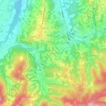
Name: Vasco topographic map, elevation, terrain.
Location: Vasco, Monastero di Vasco, Cuneo, Piedmont, 12080, Italy (44.33066 7.80712 44.37066 7.84712)
Average elevation: 1,788 ft
Minimum elevation: 1,401 ft
Maximum elevation: 2,362 ft
Thank you for supporting this site ❤️
Make a donation
Make a donation
Gear up for your next adventure:
As an Amazon Associate, this site earns from qualifying purchases at no extra cost to you.