
Tehran Province topographic map
Click on the map to display elevation.
About this map
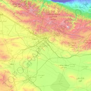
Name: Tehran Province topographic map, elevation, terrain.
Location: Tehran Province, Iran (34.86524 50.33279 36.10161 53.15690)
Average elevation: 4,708 ft
Minimum elevation: -95 ft
Maximum elevation: 17,897 ft
Other topographic maps
Click on a map to view its topography, its elevation and its terrain.
Zagros Mountains
Iran > Isfahan Province > Semirom County > Padena-ye Vosta RD
Average elevation: 12,618 ft
Pust Forush
Iran > Razavi Khorasan > Zeberkhan County > Zebarkhan Rural District
Average elevation: 4,465 ft
Kordichal
Iran > Mazandaran Province > Kelardasht County > دهستان کلاردشت شرقی
Average elevation: 4,052 ft
Mansur-e Aqa'i
Iran > Kermanshah Province > Ravansar County > دهستان منصورآقایی
Average elevation: 5,738 ft
Tochal
Iran > Tehran Province > Shemiranat County > دهستان رودبار قصران
Tochal (Persian: توچال Točāl), is a mountain and ski resort located on the Alborz mountain range, adjacent to the metropolitan area of Tehran in northern Iran. It includes a 12-kilometre-long (7.5 mi) ridge. Its highest peak, also called Tochal, is at an elevation of 3,963 metres (13,002 ft) above sea level.
Average elevation: 11,683 ft
Qarah Bashlu
Iran > North Khorasan Province > Bojnurd County > دهستان آلاداغ
Average elevation: 4,318 ft
HajiAbad
Iran > Lorestan Province > Delfan County > East Kakavand Rural District > Haft Cheshmeh
Average elevation: 5,630 ft
Deh-e Molla Bozorg
Iran > Khuzestan Province > Hendijan County > دهستان سورین
Average elevation: 49 ft
Zagros Mountains
Iran > Isfahan Province > Semirom County > Padena-ye Vosta RD
Average elevation: 12,618 ft
Khatunabad
Iran > Kerman Province > Shahr-e-Babak County > دهستان خاتون آباد
Average elevation: 6,073 ft
Minoo Island
Iran > Khuzestan Province > Khoramshahr County > دهستان جزیره مینو
Average elevation: 7 ft
قلعه گبری (ایرج)
Iran > Tehran Province > Pishva County > Asgariyeh RD > عسگرآباد عباسی > قلعه گبری
Average elevation: 3,097 ft
Kharvana
Iran > East Azerbaijan Province > Varzaqan County > دهستان دیزمارمرکزی
Average elevation: 4,885 ft
علویان
Iran > East Azerbaijan Province > Maragheh County > دهستان سراجوی غربی
Average elevation: 5,089 ft
Malek Abad
Iran > Sistan and Baluchestan Province > Zahedan County > دهستان حرمک
Average elevation: 3,140 ft
Malekabad
Iran > Lorestan Province > Delfan County > دهستان میربگ شمالی > Cheraghabad
Average elevation: 5,896 ft
جاده میانکاله
Iran > Golestan Province > Torkaman County > South Chaparbay District > آشوراده
Average elevation: -89 ft
Baladeh
Iran > Mazandaran Province > Nur County > دهستان شیخ فضل الله نوری
Average elevation: 8,031 ft
چناقچی
Iran > East Azerbaijan Province > Khoda Afarin County > دهستان کیوان
Average elevation: 1,342 ft
Sabalan
Iran > Ardabil Province > Meshkinshahr County > دهستان لاهرود
At 4,794 metres (15,728 ft) in elevation, it is the third-highest mountain in Iran. It has a permanent crater lake formed at its summit. On one of its slopes around 3,600 metres (11,800 ft) in elevation there are large rock formations of eroded volcanic outcrops that resemble animals, birds, and insects.
Average elevation: 14,045 ft
Iranian plateau
Iran > South Khorasan Province > Tabas County > دهستان دیهوک
The northwestern Iranian plateau, where the Pontic and Taurus Mountains converge, is rugged country with higher elevations, a more severe climate, and greater precipitation than are found on the Anatolian plateau. The region is known as the Anti-Taurus, and the average elevation of its peaks exceeds 3,000 m…
Average elevation: 3,481 ft
Damavand
Iran > Mazandaran Province > Amol County > دهستان لاریجان سفلی
Mount Damavand (Persian: دماوند [dæmɒːvænd] ) is a dormant stratovolcano and is the highest peak in Iran and Western Asia, the highest volcano in Asia, and the 3rd highest volcano in the Eastern Hemisphere (after Mount Kilimanjaro and Mount Elbrus), at an elevation of 5,609 metres (18,402 ft).…
Average elevation: 16,237 ft
Kermanshah
The province's capital is Kermanshah, located in the middle of the western part of Iran. The population of the city is 946,651 as of 2016. It is built on the slopes of Mt. Sefid Kooh and extended toward south during last two decades. The built-up areas run alongside Sarab River and Sarab Valley. The city's…
Average elevation: 3,458 ft
Damavand
Iran > Mazandaran Province > Amol County > دهستان لاریجان سفلی
Mount Damavand (Persian: دماوند [dæmɒːˈvænd] English: /dɔːmoʊˈvænd/ Da-moh-VAND) is a dormant stratovolcano in Iran. It is the highest peak in Iran and Western Asia, the highest volcano in Asia, and the 3rd highest volcano in the Eastern Hemisphere (after Mount Kilimanjaro and Mount Elbrus), at…
Average elevation: 16,237 ft
Damavand
Iran > Mazandaran Province > Amol County > دهستان لاریجان سفلی
Mount Damavand (Persian: دماوند [dæmɒːvænd] ) is a dormant stratovolcano and is the highest peak in Iran and Western Asia, the highest volcano in Asia, and the 3rd highest volcano in the Eastern Hemisphere (after Mount Kilimanjaro and Mount Elbrus), at an elevation of 5,609 metres (18,402 ft).…
Average elevation: 16,237 ft
Namak Abrud
Iran > Mazandaran Province > Chalus County > دهستان کلارستاق غربی
Average elevation: 518 ft
Khalifan, Mahabad
Iran > West Azerbaijan Province > Mahabad County > دهستان کانی بازار
Average elevation: 5,112 ft
Chaldran
Iran > West Azerbaijan Province > Chaldoran County > دهستان چالدران شمالی > Chaldran
Average elevation: 6,217 ft
Alborz Mountains
Iran > Mazandaran Province > Amol County > دهستان لاریجان سفلی
While the southern slopes of the Alborz Mountains are usually semiarid or arid, with irregular and low precipitation, the northern slopes of the range are usually humid, especially in the western parts of the Central Alborz. The Alborz is the easternmost extent of many European plant species. In the southern…
Average elevation: 16,188 ft
Nik Shahr
Iran > Sistan and Baluchestan Province > Nikshahr County > دهستان هیچان
Average elevation: 1,644 ft
Gazan-e Bala
Iran > Kurdistan Province > Sanandaj County > دهستان حسین آبادجنوبی
Average elevation: 6,332 ft