
Make a donation
Gear up for your next adventure:
As an Amazon Associate, this site earns from qualifying purchases at no extra cost to you.
Höchsten topographic map
Click on the map to display elevation.
Make a donation
Gear up for your next adventure:
As an Amazon Associate, this site earns from qualifying purchases at no extra cost to you.
Höchsten
Der Höchsten liegt auf der Grenze zwischen dem Bodenseekreis mit der Gemeinde Deggenhausertal im Süden und dem Landkreis Sigmaringen mit der Gemeinde Illmensee im Norden. Auch die Gemeinde Wilhelmsdorf im Landkreis Ravensburg hat Anteile am Berg. Auf dem Höhenrücken liegen die zu Illmensee gehörende Ortschaft Glashütten und der zu Deggenhausertal gehörende Weiler Rubacker.
Make a donation
Gear up for your next adventure:
As an Amazon Associate, this site earns from qualifying purchases at no extra cost to you.
About this map
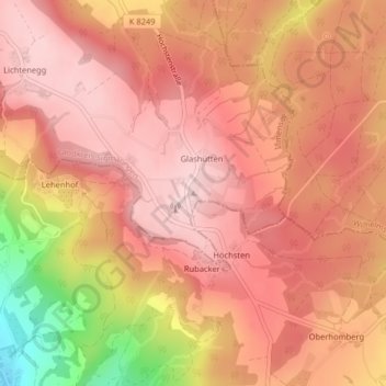
Name: Höchsten topographic map, elevation, terrain.
Average elevation: 2,487 ft
Minimum elevation: 1,814 ft
Maximum elevation: 2,756 ft
Make a donation
Gear up for your next adventure:
As an Amazon Associate, this site earns from qualifying purchases at no extra cost to you.
Other topographic maps
Click on a map to view its topography, its elevation and its terrain.
88636
Deutschland > Baden-Württemberg > Landkreis Sigmaringen > Illmensee > Reute
Average elevation: 2,303 ft