Geolocate

Cali topographic map

Click on the map to display elevation.

About this map

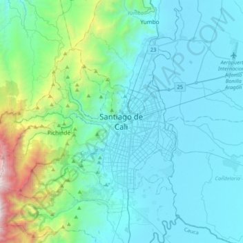
Name: Cali topographic map, elevation, terrain.

Location: Cali, Sur, Valle del Cauca, 760044, Colombia (3.29179 -76.69249 3.61179 -76.37249)

Average elevation: 4,406 ft

Minimum elevation: 3,084 ft

Maximum elevation: 12,608 ft

Other topographic maps

Click on a map to view its topography, its elevation and its terrain.

Chapinero

Colombia > Valle del Cauca > Cali > Cali

Average elevation: 3,136 ft

Alfonso Bonilla Aragón

Colombia > Valle del Cauca > Cali > Cali

Average elevation: 3,117 ft

Comuna 19

Colombia > Valle del Cauca > Cali > Cali

Average elevation: 3,369 ft

Gear up for your next adventure:

🪶Paracord Bracelet - Survival bracelet with built‑in tools
🔌Solar Panel Charger - Charge gear sustainably outdoors
🛰️Satellite Messengers - Emergency SOS and two-way messaging for off-grid adventures
🔭Stargazing Telescopes - Perfect for camping in low-light pollution areas shown on maps
🪶Fire Starter Kit - Reliable fire starter for survival and camping

As an Amazon Associate, this site earns from qualifying purchases at no extra cost to you.