
Thank you for supporting this site ❤️
Make a donation
Make a donation
Gear up for your next adventure:
As an Amazon Associate, this site earns from qualifying purchases at no extra cost to you.
Alcuneza topographic map
Click on the map to display elevation.
Thank you for supporting this site ❤️
Make a donation
Make a donation
Gear up for your next adventure:
As an Amazon Associate, this site earns from qualifying purchases at no extra cost to you.
About this map
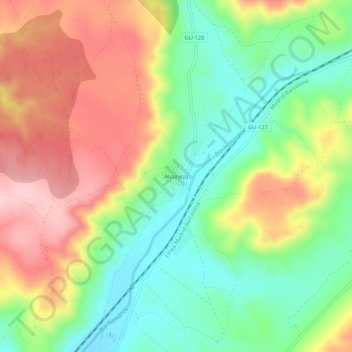
Name: Alcuneza topographic map, elevation, terrain.
Location: Alcuneza, Sigüenza, Guadalajara, Castilla-La Mancha, España (41.08489 -2.62651 41.12489 -2.58651)
Average elevation: 3,563 ft
Minimum elevation: 3,264 ft
Maximum elevation: 3,927 ft
Thank you for supporting this site ❤️
Make a donation
Make a donation
Gear up for your next adventure:
As an Amazon Associate, this site earns from qualifying purchases at no extra cost to you.
Other topographic maps
Click on a map to view its topography, its elevation and its terrain.