Geolocate

Geneva topographic map

Click on the map to display elevation.

About this map
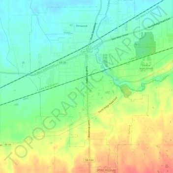
Name: Geneva topographic map, elevation, terrain.

Location: Geneva, Geneva Township, Ashtabula County, Ohio, 44041, United States (41.77945 -80.96701 41.81818 -80.92473)

Average elevation: 699 ft

Minimum elevation: 627 ft

Maximum elevation: 797 ft

Ashtabula County trails, hiking, mountain biking, running and outdoor activities

Other topographic maps

Click on a map to view its topography, its elevation and its terrain.
Pierpont

United States > Ohio > Ashtabula County

Average elevation: 1,001 ft

Chapel

United States > Ohio > Ashtabula County

Average elevation: 846 ft

Phelps Creek

United States > Ohio > Ashtabula County

Average elevation: 1,070 ft

Pierpont

United States > Ohio > Ashtabula County

Average elevation: 1,001 ft

Gear up for your next adventure:

🩹Survival Bandages - High‑quality bandages for emergencies
🛰️Handheld GPS Units - Professional satellite navigators for precise backcountry mapping
☕Camping Coffee Makers - Enjoy premium coffee at the summit or campsite
🚁Photography Drones - Capture stunning aerial views of landforms and topography
🚪Portable Camp Chair - Foldable chair for comfort at camp

As an Amazon Associate, this site earns from qualifying purchases at no extra cost to you.