Geolocate

Thorpe topographic map

Click on the map to display elevation.

Thorpe

Elevations are modest but not flat, ranging between 14 and 20m Ordnance Datum as much of the area lies on thin alluvium overlying gravel beds laid over millennia by the River Thames which adjoins the traditional parish to the east.

Wikipedia (CC-BY-SA 3.0)

About this map

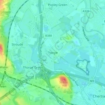
Name: Thorpe topographic map, elevation, terrain.

Location: Thorpe, Borough of Runnymede, Surrey, England, TW20 8UE, United Kingdom (51.38891 -0.55296 51.42891 -0.51296)

Average elevation: 62 ft

Minimum elevation: 26 ft

Maximum elevation: 233 ft

Gear up for your next adventure:

🩳Quick‑Dry Hiking Shorts - Comfortable and quick‑dry shorts for summer hiking
🥄Camping Utensil Set - Lightweight utensils for outdoor meals
📦Gear Storage Bags - Organize and protect outdoor equipment
🧭Pro Hiking Compasses - High-accuracy liquid-filled compasses for topographic orientation
📚Navigation Handbooks - Master the art of reading topographic maps and using a compass

As an Amazon Associate, this site earns from qualifying purchases at no extra cost to you.