
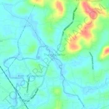
Thalakkadathur topographic map
Interactive map
Click on the map to display elevation.
About this map
Name: Thalakkadathur topographic map, elevation, terrain.
Average elevation: 66 ft
Minimum elevation: -10 ft
Maximum elevation: 279 ft
Other topographic maps
Click on a map to view its topography, its elevation and its terrain.
Poongottukulam
India > Kerala > Tirur > Poongottukulam
Poongottukulam, Tirur, Malappuram, Kerala, 676101, India
Average elevation: 39 ft
Kadampuzha
India > Kerala > Tirur > Kadampuzha
Kadampuzha, Tirur, Malappuram, Kerala, 676553, India
Average elevation: 299 ft
Marakkara
India > Kerala > Tirur > Puthanathani
Marakkara, Puthanathani, Tirur, Malappuram, Kerala, 676552, India
Average elevation: 249 ft
Valanchery
Valanchery, Tirur, Malappuram, Kerala, 676552, India
Average elevation: 151 ft