
Addison Township topographic map
Click on the map to display elevation.
About this map
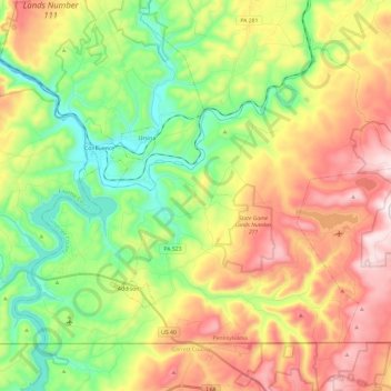
Name: Addison Township topographic map, elevation, terrain.
Average elevation: 2,090 ft
Minimum elevation: 1,270 ft
Maximum elevation: 3,199 ft
Somerset County trails, hiking, mountain biking, running and outdoor activities
Other topographic maps
Click on a map to view its topography, its elevation and its terrain.
Pike's Peak
United States > Pennsylvania > Somerset County > Jenner Township
Average elevation: 2,684 ft
Kantner
United States > Pennsylvania > Somerset County > Quemahoning Township
Average elevation: 1,995 ft
Hollsopple
United States > Pennsylvania > Somerset County > Conemaugh Township
Average elevation: 1,788 ft
Listie
United States > Pennsylvania > Somerset County > Somerset Township > Listie
Average elevation: 2,238 ft
Boynton
United States > Pennsylvania > Somerset County > Elk Lick Township > Boynton
Average elevation: 2,152 ft
Bearwallow Mountain
United States > Pennsylvania > Somerset County > Fairhope Township
Average elevation: 2,165 ft
Ralphton
United States > Pennsylvania > Somerset County > Quemahoning Township > Ralphton
Average elevation: 2,087 ft