Geolocate

Lake Constance topographic map

Click on the map to display elevation.

About this map
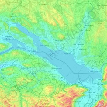
Name: Lake Constance topographic map, elevation, terrain.

Location: Lake Constance, Bodenseekreis, Baden-Württemberg, Germany (47.47806 8.85870 47.81752 9.75383)

Average elevation: 1,821 ft

Minimum elevation: 1,276 ft

Maximum elevation: 4,888 ft

Other topographic maps

Click on a map to view its topography, its elevation and its terrain.
Deisendorf

Germany > Baden-Württemberg > Bodenseekreis > Überlingen

Average elevation: 1,522 ft

Berg

Germany > Baden-Württemberg > Bodenseekreis

Average elevation: 1,453 ft

Gear up for your next adventure:

🧦Hiking Socks - Comfortable socks to prevent blisters on long hikes
📦Dry Bags Set - Waterproof storage for electronics and clothes
📡GPS Antenna Upgrade - Enhance GPS reception in remote terrain
🧭Compass with Lanyard - Easy‑carry compass for navigation
🎒Trekking Poles - Sturdy poles for balance and stability on rough terrain

As an Amazon Associate, this site earns from qualifying purchases at no extra cost to you.