
Make a donation
Gear up for your next adventure:
As an Amazon Associate, this site earns from qualifying purchases at no extra cost to you.
Parque Bicentenario topographic map
Click on the map to display elevation.
Make a donation
Gear up for your next adventure:
As an Amazon Associate, this site earns from qualifying purchases at no extra cost to you.
About this map
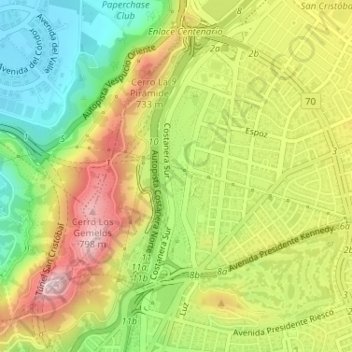
Name: Parque Bicentenario topographic map, elevation, terrain.
Average elevation: 2,123 ft
Minimum elevation: 1,670 ft
Maximum elevation: 2,625 ft
Make a donation
Gear up for your next adventure:
As an Amazon Associate, this site earns from qualifying purchases at no extra cost to you.
Other topographic maps
Click on a map to view its topography, its elevation and its terrain.
Mirador Los Gemelos
Chile > Región Metropolitana de Santiago > Provincia de Santiago > Vitacura
Average elevation: 2,060 ft
Parque Bicentenario
Chile > Región Metropolitana de Santiago > Provincia de Santiago > Vitacura
Average elevation: 2,123 ft
Cerro Manquehue
Chile > Región Metropolitana de Santiago > Provincia de Santiago > Vitacura
Average elevation: 3,881 ft
Parque Bicentenario
Chile > Región Metropolitana de Santiago > Provincia de Santiago > Vitacura
Average elevation: 2,123 ft
Make a donation
Gear up for your next adventure:
As an Amazon Associate, this site earns from qualifying purchases at no extra cost to you.
Parque Bicentenario
Chile > Región Metropolitana de Santiago > Provincia de Santiago > Vitacura
Average elevation: 2,123 ft