Geolocate

Stepps topographic map

Click on the map to display elevation.

About this map

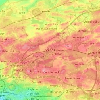
Name: Stepps topographic map, elevation, terrain.

Location: Stepps, North Lanarkshire, Scotland, G33 6HB, United Kingdom (55.85090 -4.18598 55.93090 -4.10598)

Average elevation: 240 ft

Minimum elevation: 39 ft

Maximum elevation: 364 ft

Gear up for your next adventure:

🔥Plasma Lighters - Windproof lighters that work in any weather condition
🖼️Topo Map Wall Art - Decorative topographic prints of famous peaks and regions
🕶️GPS Smartphone Mount - Secure mount for phone navigation
🛡️Bear Spray Outdoor - Protection in bear country hikes
🔋Solar Power Banks - Keep your GPS and phone charged in remote wilderness areas

As an Amazon Associate, this site earns from qualifying purchases at no extra cost to you.