
Río Apure topographic map
Interactive map
Click on the map to display elevation.
About this map
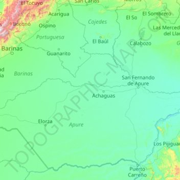
Name: Río Apure topographic map, elevation, terrain.
Location: Río Apure, Municipio Achaguas, Apure, 7001, Venezuela (7.57311 -70.32820 8.06996 -66.39886)
Average elevation: 518 ft
Minimum elevation: 69 ft
Maximum elevation: 11,880 ft
Other topographic maps
Click on a map to view its topography, its elevation and its terrain.
Parque Nacional El Tamá
Parque Nacional El Tamá, Municipio Páez, Apure, Venezuela
Average elevation: 2,841 ft
El Samán de Apure
Venezuela > Apure > El Samán de Apure
El Samán de Apure, Municipio Achaguas, Apure, Venezuela
Average elevation: 220 ft