Geolocate

Tala topographic map

Click on the map to display elevation.

👉 Easily get elevation data in JSON, GeoTIFF and KML formats using Elevation API
Thank you for supporting this site ❤️
Make a donation

About this map

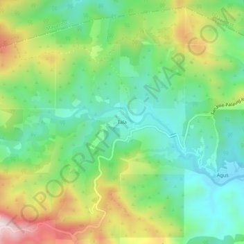
Name: Tala topographic map, elevation, terrain.

Location: Tala, San Jose, Tarlac, Central Luzon, Philippines (15.48446 120.31360 15.52446 120.35360)

Average elevation: 1,250 ft

Minimum elevation: 650 ft

Maximum elevation: 2,339 ft

Other topographic maps

Click on a map to view its topography, its elevation and its terrain.

Bulsa River

Philippines > Tarlac > San Jose

Average elevation: 325 ft

Gear up for your next adventure:

🕶️GPS Smartphone Mount - Secure mount for phone navigation
🎒Day Hiking Backpack - Lightweight backpack perfect for day trips and outdoor adventures
Solar GPS Watches - Advanced multisport watches with built-in topographic maps
🪶Survival Guide Book - Expert advice for emergency preparedness
🗺️NatGeo Topo Maps - High-quality waterproof printed topographic maps of US Parks

As an Amazon Associate, this site earns from qualifying purchases at no extra cost to you.