Geolocate

Loon Lake topographic map

Click on the map to display elevation.

About this map
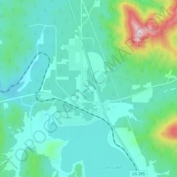
Name: Loon Lake topographic map, elevation, terrain.

Location: Loon Lake, Stevens County, Washington, United States (48.04079 -117.65705 48.09253 -117.60096)

Average elevation: 2,556 ft

Minimum elevation: 2,293 ft

Maximum elevation: 3,694 ft

Stevens County trails, hiking, mountain biking, running and outdoor activities

Other topographic maps

Click on a map to view its topography, its elevation and its terrain.

Ford

United States > Washington > Stevens County

Ford is located in a mountainous area at the base of Happy Hill, which rises more than 600 feet immediately to the southeast of the community. The northeast–southwest trending Walkers Prairie and valley floor along which Chamokane Creek flows is relatively flat and at an elevation of between 1,700 and 1,800…

Average elevation: 1,893 ft
Grays

United States > Washington > Stevens County

Average elevation: 1,962 ft

Bissel

United States > Washington > Stevens County

Average elevation: 2,110 ft

Enterprise

United States > Washington > Stevens County

Average elevation: 1,962 ft

Tumtum

United States > Washington > Stevens County

Average elevation: 1,821 ft

Suncrest

United States > Washington > Stevens County

Average elevation: 1,854 ft

Wellpinit

United States > Washington > Stevens County

Average elevation: 2,500 ft

Turk

United States > Washington > Stevens County

Average elevation: 3,114 ft

Gifford

United States > Washington > Stevens County

Average elevation: 1,650 ft

Onion Creek

United States > Washington > Stevens County

Average elevation: 2,759 ft

Rice

United States > Washington > Stevens County

Average elevation: 1,759 ft

Suncrest

United States > Washington > Stevens County

Average elevation: 1,854 ft

Colville

United States > Washington > Stevens County > Colville > Colville

Average elevation: 1,975 ft

Ford

United States > Washington > Stevens County

Ford is located in a mountainous area at the base of Happy Hill, which rises more than 600 feet immediately to the southeast of the community. The northeast–southwest trending Walkers Prairie and valley floor along which Chamokane Creek flows is relatively flat and at an elevation of between 1,700 and 1,800…

Average elevation: 1,893 ft
Velvet

United States > Washington > Stevens County

Average elevation: 2,671 ft

Rocky Butte

United States > Washington > Stevens County

Average elevation: 3,346 ft

Calispell Peak

United States > Washington > Stevens County

Average elevation: 5,801 ft

Mount Rogers

United States > Washington > Stevens County

Average elevation: 4,715 ft

Gear up for your next adventure:

🛏️Cold Weather Sleeping Bag - Warm sleeping bag for cold conditions
📱Solar Portable Charger - Solar power bank for charging devices off‑grid
🔭Compact Binoculars - HD vision for scouting terrain and identifying distant landmarks
🪶Trail Camera - Capture wildlife on your hikes
🧭Map Reading Tools - Tools and kits for map navigation

As an Amazon Associate, this site earns from qualifying purchases at no extra cost to you.