
Make a donation
Gear up for your next adventure:
As an Amazon Associate, this site earns from qualifying purchases at no extra cost to you.
Kleinlesau topographic map
Click on the map to display elevation.
Make a donation
Gear up for your next adventure:
As an Amazon Associate, this site earns from qualifying purchases at no extra cost to you.
Kleinlesau
Altenhof | Arnleithen | Elbersberg | Geusmanns | Graisch | Haselbrunn | Haßlach | Hohenmirsberg | Kirchenbirkig | Kleinkirchenbirkig | Kleinlesau | Kühlenfels | Leienfels | Mandlau | Mittelmühle | Neu-Geusmanns | Pottenstein | Prüllsbirkig | Pullendorf | Püttlach | Rackersberg | Regenthal | Rupprechtshöhe | Schüttersmühle | Siegmannsbrunn | Soranger | Steifling | Trägweis | Tüchersfeld | Vorderkleebach | Waidach | Wannberg | Weidenhüll bei Elbersberg | Weidenhüll bei Leienfels | Weidenhüll-Knock | Weidenloh | Weidmannsgesees
Make a donation
Gear up for your next adventure:
As an Amazon Associate, this site earns from qualifying purchases at no extra cost to you.
About this map
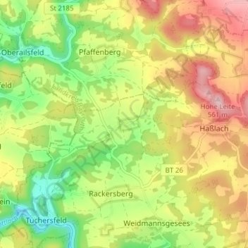
Name: Kleinlesau topographic map, elevation, terrain.
Average elevation: 1,414 ft
Minimum elevation: 1,089 ft
Maximum elevation: 1,765 ft
Make a donation
Gear up for your next adventure:
As an Amazon Associate, this site earns from qualifying purchases at no extra cost to you.